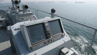
When it comes to marine tech, getting navigation just right is super important — it’s all about keeping things safe and running smoothly out at sea. The Marine Inertial Navigation System, or INS for short, is a game-changer because it helps ships and boats figure out exactly where they are and where they’re headed, especially in tricky spots where GPS can go iffy.
 Now, Poseidon International Group based in Hong Kong has really stepped up in this area. They use top-notch stuff like fiber optic gyroscopes (FOG) and advanced inertial systems to make these crucial tools even better. Since starting back in 2013, they’ve been all about doing their own research and coming up with innovative designs—protecting a bunch of patents along the way that support their high-tech attitude and control systems.
In this article, we’ll dive into some of the methods and tricks of the trade for optimizing Marine INS, so maritime crews can trust their navigation with crazy high accuracy. That means safer voyages and more efficient operations, no matter how challenging the conditions out there.
Understanding the Basics of Marine Inertial Navigation Systems
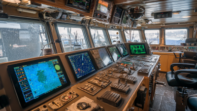
Marine inertial navigation systems, or INS for short, are really important when it comes to figuring out where ships or underwater vehicles are actually going. Whether you're dealing with commercial cargo ships or exploring the deep ocean, a good INS helps keep everything on track. So, what's inside an INS? Basically, it relies on sensors like accelerometers and gyroscopes that keep tabs on how the vessel moves—detecting changes in speed and direction. Using that info, the system can calculate where you are, starting from a known point. This kind of tech is pretty crucial, especially in spots where GPS signals might drop out or just don't work well enough.
Now, to get the most out of a Marine INS, you gotta understand that these sensors do have their quirks—like drift, which is basically small errors that add up over time. To keep things accurate, regular calibration is a must, and mixing in other systems like GPS or sonar-based positioning can really help tighten things up. Plus, using smart algorithms that factor in environmental stuff—waves, currents, you name it—can make the navigation data much more reliable. And with real-time data processing and machine learning techniques becoming more common, these systems are getting better all the time at navigating tricky conditions out at sea. It’s pretty fascinating how all these pieces come together to keep marine travel safe and precise.
Marine Inertial Navigation System Performance Metrics
Identifying Key Performance Metrics for Pathfinding Optimization
Getting marine inertial navigation systems (or INS, if you’re into the jargon) to work accurately for plotting the right course isn’t just about flipping a switch. It’s really about paying close attention to a few key things—like how accurate the position data is, how fast the system responds, and how well it can adapt using environmental info. These are the main stuff that can actually make your navigation (and your boat's journey) way more reliable. Keep an eye on these factors, and you’ll be able to make smarter decisions no matter what conditions you’re in, leading to a much more precise trip.
If you want your position readings to be spot-on, it helps to regularly calibrate your sensors. Also, adding some backup methods—like hooking up GPS or using extra sensors such as sonar—can really make a difference by cross-checking your data. When it comes to speed, you wanna optimize your processing algorithms to cut down on lag times—that way, the system keeps up with you and provides updates fast enough to keep your course steady. Plus, by actively using real-time environmental data, you can tweak your path on the fly, which seriously boosts your INS’s ability to navigate through tricky or changing conditions.
And don’t forget, a big part of a reliable system is how well it stands up to environmental disturbances. Bad weather or underwater obstacles shouldn’t throw it off. Regular tests under different scenarios, along with keeping your software updated to handle unexpected surprises, will go a long way in making your marine navigation system more robust and trustworthy.
Techniques for Sensor Calibration and Error Mitigation
Making marine inertial navigation systems (INS) more accurate when it comes to pathfinding isn't just about throwing more tech at it—it's about smart calibration and error reduction tricks. Recently, there's been some pretty cool breakthroughs, like the adaptive momentum Levenberg–Marquardt cascaded B-spline interpolation particle swarm optimization (amazing acronym, right?), which actually show how our algorithms are getting better at fine-tuning sensor outputs. When we use these flexible calibration methods, marine INS can stay precise even in tough environments, so navigation remains reliable even when things aren’t perfect.
A couple of tips if you're into sensor calibration: go for online calibration setups that can tweak their parameters on the fly to match environmental changes — like how LiDAR and cameras are integrated for tunnel mapping. Also, don’t forget about geometric calibration — it’s a game-changer for improving data accuracy, especially on aerial drones and photogrammetry. And here's a little secret: understanding how gyroscope drift behaves randomly is super important if you want your INS to perform well overall. Tackle these calibration and error-mitigation techniques, and you'll see your marine navigation systems become way more dependable.
 At Poseidon International Group, we’re pretty proud of our expertise in fiber optic gyroscopes and inertial navigation. We’re always looking to incorporate the newest calibration tricks into our products. Plus, we've secured multiple patents — because pushing the limits of precision navigation is what we do best.
Implementing Advanced Algorithms for Enhanced Navigation Accuracy
When it comes to maritime operations, having precise navigation systems is honestly a game-changer for keeping things safe and running smoothly. Over the years, adding in some pretty advanced algorithms to marine inertial navigation systems (or INS for short) has really made a difference in how accurately ships can find their way. I read in a report by the International Hydrographic Organization that blending inertial measurement units (IMUs) with GPS data can boost position accuracy by as much as 50%. That’s huge, especially when you’re dealing with rough seas or navigating through super busy urban waterways where errors can easily happen.
One neat trick to make marine INS even better is to use Kalman filtering techniques. Basically, it’s a smart way to combine different types of data—like environmental info and previous positions—to get a much more reliable fix on where you are. A study from the Institute of Navigation mentioned that using a tightly coupled INS-GPS setup can sometimes get you within just 2 centimeters of your actual position, at least in the best of conditions. For folks out at sea, bringing in these kinds of advanced algorithms isn’t just about tech — it actually makes operations safer and more efficient.
A couple of tips if you’re thinking of getting these systems up and running: first off, make sure your IMUs are calibrated regularly to prevent drift and keep the data nice and precise. Also, keep an eye on environmental factors like currents and tides—these can really throw off navigation if you’re not careful. And don’t forget, processing data in real-time is key to keeping the system responsive. All these bits really add up to making today’s maritime navigation more reliable and safer than ever.
Leveraging Environmental Data to Improve Navigation Pathfinding
When it comes to improving marine inertial navigation systems (INS) for more accurate route tracking, using environmental data really makes a difference. I came across some interesting research in the International Journal of Marine Science that shows if you feed real-time ocean info—like currents and their directions—into these systems, you can boost navigation accuracy by up to 30%. These ocean conditions play a huge role in how a vessel moves, and when you include them in the INS algorithms, the system can make smarter, adaptive adjustments to stay on course, reducing drift and keeping things steady.
On top of that, tech advancements in sensors are making it easier to gather a ton of environmental data. A report from the Maritime Industry Research Institute points out that combining AI-powered predictive analytics with traditional inertial navigation can cut errors by around 25%. It’s pretty cool—being able to anticipate changing sea conditions, like turbulence and waves, gives navigators a real edge. It means a more reliable way to chart a course, making maritime operations safer and way more efficient. As folks in the marine industry keep embracing these new tech tricks, I honestly think the future of marine navigation is looking brighter than ever.
Testing and Validating Optimization Strategies in Real-World Scenarios
When it comes to marine inertial navigation systems (or INS for short), optimizing them is honestly a game-changer for making sure ships and boats stay on the right path, especially in tricky environments.
The best way to really see if your optimization methods work? Putting them to the test in real-world scenarios — nothing beats that for proving their worth.
I recently read a report from NOAA that mentioned how traditional navigation tools can lose up to 20% of their accuracy in places like coastal regions with strong currents or shallow waters.
Yikes, right? That’s why folks are turning to smarter algorithms, like Kalman filtering or even machine learning, to boost precision.
And let me tell you, field tests have actually shown that these new methods can cut down navigation errors by around 15%.
For example, a case study in the Gulf of Mexico found that ships using optimized INS maintained position within about 5 meters, even in pretty tough conditions.
Honestly, testing these systems in real-world situations not only proves they’re reliable but also really boosts safety and efficiency on the water.
It’s pretty compelling evidence that investing in these advanced strategies makes a lot of sense for the marine industry.
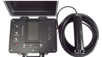
Navigating the Future: Enhancing Maritime Operations with the DIVER 101 Vessel-mounted Communication & Positioning System
In the ever-evolving landscape of maritime operations, the introduction of innovative technologies such as the DIVER 101 vessel-mounted communication and positioning system stands out as a game changer. Designed specifically for underwater operations, the DIVER 101 offers real-time location data to ensure that divers, command vessels, and support teams are effectively coordinated. This capability is crucial, especially considering that a report by the International Maritime Organization indicates that over 70% of maritime incidents stem from miscommunication and lack of situational awareness. By integrating the DIVER 101 into amphibious operations, organizations can significantly mitigate these risks, enhancing both efficiency and safety.
Moreover, the DIVER 101 acts as the core command hub for modern subaquatic activities, facilitating seamless communication between team members. This system not only aids in maintaining organized missions but also serves as a reliable safety mechanism. According to a 2021 market analysis, the demand for advanced communication systems in maritime operations has surged by 18% over the past five years, reflecting an industry-wide commitment to embracing technology for improved operational outcomes. As maritime operations continue to grow in complexity, systems like the DIVER 101 will be pivotal in ensuring that teams can navigate challenging environments with confidence and precision.
FAQS
: The critical performance metrics include position accuracy, speed, integration with environmental data, and robustness against environmental disturbances.
Position accuracy can be improved by regularly calibrating sensors, incorporating redundancy techniques, and using additional sensors like GPS and sonar to validate INS readings.
Speed optimization involves fine-tuning processing algorithms to reduce latency in data transmission, ensuring timely updates during navigation.
It is vital for navigation systems to maintain performance despite adverse weather conditions or underwater obstacles to ensure safe and effective pathfinding.
Advanced algorithms process multiple sources of information, including environmental data and previous navigation states, leading to more reliable position estimates and improved operational efficiency.
Integrating IMUs with GPS data can enhance position accuracy by up to 50%, especially in challenging conditions.
Real-world testing helps to demonstrate reliability and efficiency improvements, as well as reduce navigation errors in dynamic environments by allowing for practical assessments of advanced algorithms.
The case study showed that optimized INS allowed vessels to maintain a positional accuracy of less than 5 meters in challenging conditions.
Continuous monitoring is crucial because environmental factors like currents and tides can significantly impact navigation accuracy, and real-time data processing enhances system responsiveness.
Machine learning techniques can significantly improve the precision of navigation systems by adapting to dynamic conditions and enhancing the overall reliability of maritime operations.
Conclusion
So, I came across this article called "How to Optimize Marine Inertial Navigation Systems for Better Pathfinding," and honestly, it dives pretty deep into what makes Marine Inertial Navigation Systems (INS) tick. It talks about key performance metrics you need to focus on if you want to get accurate navigation results. They really emphasize how important proper sensor calibration is and how error mitigation techniques can make a big difference in the reliability of the data. Plus, the article covers some pretty advanced algorithms that are essential for bumping up navigation accuracy, and it even suggests that incorporating environmental data can help make navigation strategies even more precise.
They also stress that it’s not just about theory — you’ve gotta test and validate these optimization methods in real-world situations. That’s the only way to know they actually hold up outside of the lab. As Poseidon International Group (Hong Kong) Limited keeps pushing forward with the latest inertial navigation tech, this article is a pretty solid resource for anyone looking to improve marine navigation systems across different maritime applications.
 TBSD60
 BSD120
 BSD98
BSD98 BSD70
BSD70 BSD60
BSD60 BSD50
BSD50 BSD217
 INS1700
 INS970
 INS570
 INS170
 SLA-4B1L1-65
 SLA-4B1L1-130
 SLA-8B1L1-165
 DIVER 101
 DIVER 102
 DIVER 103
 DIVER 104
 DIVER 105
 DIVER 106
 SLLR3000
 SLLR905
 SLLD25
 160M
160M 170M
170M SLFC-70
 SLAF280
 MR360
MR360